
Contents
- NG911 Required Data Layers
- Attribute Domains
- Auto Populated and Calculated Fields
- Appendix A | Quality Control Check Details
NG911 Required Data Layers
The following NG911 GIS data layers must be submitted to the state’s quality assurance/quality control system, GIS Data Hub.
- Road Centerlines (RCL)
- Site/Structure Address Points (SSAP)
- PSAP Boundaries
- Services Boundaries (ESB)
- EMS Boundaries
- Fire Boundaries
- Law Boundaries
- Provisioning Boundaries
The following E911 databases must also be provided before and during transition to NG911.
- ALI
- MSAG
Due to the nature of these resources the most current versions available to the PSAP should be included. If you need assistance please contact the GIS Specialist at OEC.
The required schema of the data submitted can be found in the WI NG9-1-1 GIS Data Model and Best Practices document found here: https://oec.wi.gov/wisconsin-ng9-1-1-gis-data-standard-best-practices/
Attribute Domains
The following attributes will be checked against a domain (list of acceptable values). Any values not a part of the domains will be marked as a quality control error.
- Discrepancy Agency ID | List provided by WI OEC
- Street Name Pre Directional | List provided by NENA
- Street Name Pre Type | List provided by NENA
- Street Name Pre Type Separator | List provided by NENA
- Street Name Post Type | List provided by NENA
- Street Name Post Directional | List provided by NENA
- Legacy Street Name Pre Directional | List provided by USPS
- Legacy Street Name Post Type | List provided by USPS
- Legacy Street Name Post Directional | List provided by USPS
- Country | US
- State | WI, IA, IL, MI, MN
- County | List provided by WI OEC
- Incorporated Municipalities | List provided by WI OEC
- Postal Codes | List provided by WI OEC
- Parity | List provided by NENA
- Structure | List provided by WLIA
- Service URN | List provided by NENA
- Service URI | List provided by AT&T
Auto Populated and Calculated Fields
The following fields can be auto populated or calculated through GIS Data Hub. Each participating jurisdiction will determine if they apply.
- Discrepancy Agency ID
- Can be auto populated if the data being submitted is a single agency (PSAP)
- Globally Unique ID
- Participating jurisdiction must provide the locally assigned portion of the ID
- GIS Data Hub can add the URN, Prefix and Discrepancy Agency ID
- Country
- State
- Can be auto populated as WI if the data is completely within WI and not a bordering county
- Service URN
- Service URI
- Can be auto populated if there is only one (1) PSAP Boundary being submitted
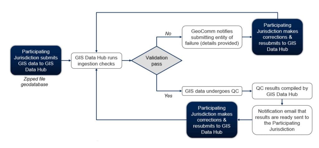
Participating Jurisdiction Submission & QC Workflow
The workflow below depicts the process of NG911 GIS data submission and quality control by the participating jurisdictions.
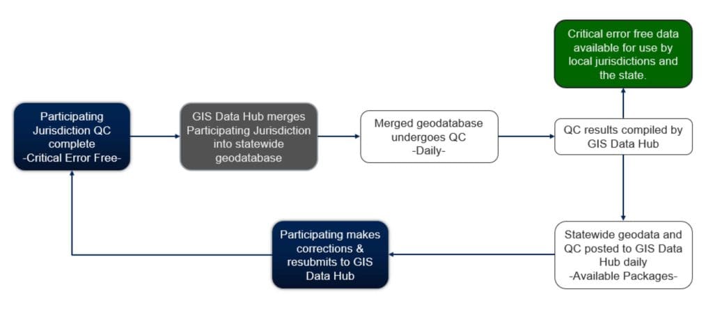
Seamless Dataset Creation & QC Workflow
The workflow below depicts the process of the creation of a seamless statewide dataset for NG911 and the quality control of the dataset.
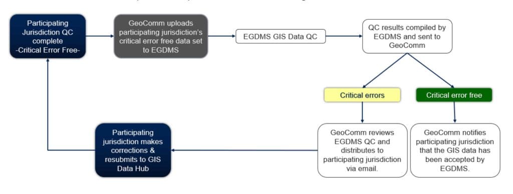
NG911 GIS Data Provisioning to EGDMS Workflow
The workflow below depicts the process of submitting NG911 GIS data to EGDMS.
Quality Control Plan
Summary and detailed quality control (QC) results can be downloaded from the GIS Data Hub’s Analytics page. The results of the latest successful data submission will always be first in the Analytics. The detailed GIS Fallout Report .csv file can be converted to a file geodatabase with feature classes using the HubHelper tool in ArcGIS Pro or ArcGIS Desktop. Instructions for downloading, installing and using HubHelper for QC results conversion can be found on the GIS Data Hub’s Available Packages page. Additional details about the individual QC check below can be found in the GIS Data Hub help file.
QC checks fall into four (4) categories:
- Ingestion Failures | Provisioning Halted
- Critical Errors (9-1-1 call routing) | Provisioning Halted
- Warnings – Call Transfers | Provisioning Continued
- Warnings – PSAP Mapping & CAD Systems | Provisioning Continued
Ingestion failures indicate an issue with the data and the data will not process until the issue is resolved. The most common issues are changes to the layer or field names. Any ingestion failures will be communicated to the participating jurisdiction by the GeoComm WI team. GeoComm will provide all the details to assist the participating jurisdiction with resolution.
Critical errors indicate an error that must be resolved for the data to be submitted to the NG911 system, EGDMS. Upon completion of QC, the participating jurisdiction must review the fallout provided by GIS Data Hub, make the appropriate updates and resubmit to GIS Data Hub.
Warnings indicate an error that should be reviewed and resolved but are not required to be resolved. Warnings are typically data issues that impact 911 systems outside of the NG911 environment.
Ingestion Failures
Details about each of the following QC checks can be found in Appendix A.
- Corrupt data in a file geodatabase
- Empty Geometry
- Complex Geometry
- Data schema changes | Layer and field names
- SSAP Duplicate Values | Stacked points with identical attributes
- Globally Unique ID
- Verify Projection | Layer with missing projection
- Exception Code Formatting
Critical Errors
Details about each of the following QC checks can be found in Appendix A.
- Null Value in a Field
- Date Update
- Discrepancy Agency ID
- NGUID
- Agency ID | PSAP, EMS, Fire, Law
- Display Name | PSAP, EMS, Fire, Law
- Service URI | PSAP, EMS, Fire, Law
- Service URN | PSAP, EMS, Fire, Law
- State | PSAP, EMS, Fire, Law, Road Centerline, Site/Structure Address Point
- Address Ranges | Road Centerline
- Country | Road Centerline, Site/Structure Address Point
- County | Road Centerline, Site/Structure Address Point
- Incorporated Municipality | Road Centerline, Site/Structure Address Point
- MSAG Community | Road Centerline, Site/Structure Address Point
- Street Name | Road Centerline, Site/Structure Address Point
- Legacy Street Name | Road Centerline, Site/Structure Address Point
- Parity | Road Centerline
- Polygon Overlap
- Provisioning Boundary
- PSAP Boundary
- Acceptable Feature Count | Must have at least one (1) polygon
- Provisioning Boundary
- Polygon Compare (Gaps)
- PSAP Boundary
- EMS Boundary
- Fire Boundary
- Law Boundary
- Polygon Compare (Overhangs)
- PSAP Boundary
- EMS Boundary
- Fire Boundary
- Law Boundary
- Multipart Geometry
- PSAP Boundary
- Road Centerline
- Unacceptable Values | Required field cannot contain a space
- Acceptable Values
- Service URI | PSAP, EMS, Fire, Law
- Service URN | PSAP, EMS, Fire, Law
- State | PSAP, EMS, Fire, Law, Road Centerline, Site/Structure Address Point
- Street Name Pre Directional | Road Centerline, Site/Structure Address Point
- Street Name Pre Type | Road Centerline, Site/Structure Address Point
- Street Name Post Type | Road Centerline, Site/Structure Address Point
- Street Name Post Directional | Road Centerline, Site/Structure Address Point
- Legacy Street Name Pre Directional | Road Centerline, Site/Structure Address Point
- Legacy Street Name Type | Road Centerline, Site/Structure Address Point
- Legacy Street Name Post Directional | Road Centerline, Site/Structure Address Point
- Parity | Road Centerline
- Country | Road Centerline, Site/Structure Address Point
- County | Road Centerline, Site/Structure Address Point
- Incorporated Municipality | Road Centerline, Site/Structure Address Point
- Address Number | Site/Structure Address Point
- Road Centerline Features Broken at Polygon
- Provisioning Boundary
- PSAP Boundary
- Road Centerline Address Range Overlap
- Feature Outside of Polygon | Provisioning Boundary
- Road Centerline
- Site/Structure Address Point
- Site/Structure Address Point Duplicate Values
Warnings
Details about each of the following QC checks can be found in Appendix A.
- ALI to Road Centerlines
- ALI to Site/Structure Address Points
- MSAG to Road Centerlines
- Site/Structure Address Points to Road Centerlines
- Road Centerline Features Broken at Polygon
- EMS Boundary
- Fire Boundary
- Law Boundary
- Single Layer Polygon Gap
- EMS Boundary
- Fire Boundary
- Law Boundary
- Polygon Overlap Check
- EMS Boundary
- Fire Boundary
- Law Boundary
- Road Centerline segment snapped to adjacent segment – same layer
- Field Comparison | Parsed fully spelled out street name to full street name
- Point to Polygon Attribute Compare | Site/Structure Address Point Incorporated Municipality to Incorporate Municipality Boundary
- Road Centerline Duplicate Value | Stacked segments
Appendix A | Quality Control Check Details
Ingestion Validation QC Checks
Verify Projection
Validates the spatial reference to ensure geometry in the source feature class can be projected into a target spatial reference for NG 9- 1-1 systems.
Exception Code: None
Details: This is a required process for GIS Data Hub system ingest.
Transformation Validation Task
Check verifies that the source data is consistent with existing field mapping information provided by the user. Also, identifies where fields are not properly formatted.
Exception Code: None
Details: This is a required process for GIS Data Hub system ingest.
Field Constraint
An attribute value is incompatible with the 9-1-1 EGDMS database schema and cannot be loaded.
Details: EGDMS
Transformation Data Validation Task
Identifies features that contain errors that prevent aggregation.
Exception Code: None
Exception Code Formatting
Identifies entries that contain invalid exception code formats, such as spaces or null values, allowing for the correction of any formatting issues to ensure that the exception codes are formatted and get applied correctly.
Exception Code: None
Details: This is a required process for GIS Data Hub system ingest.
Empty Geometry
Identifies features in a spatial feature class that contain an attribute record but no geometry.
Ecpection Code: None
Geometry Error
A record exists in the attribute table that is not associated with a geographic feature or the geometry of a feature is in error.
Details: EGDMS
Complex Geometry
Identifies records in which the geometry attribution is outside of the normal acceptable geometry to ensure the geometry attribution is valid.
Exception Code: None
Geometry Warning
A feature had invalid geometry, but that inconsistency was automatically corrected by 9-1-1 EGDMS.
Details: EGDMS
Globally Unique ID
Verifies that ID columns are unique across all feature classes.
Exception Code: None
Site/Structure Address Point QC Checks
Unacceptable Values
Identifies records containing forbidden values identified by a user in data entry allowing the invalid data to be corrected.
Exception Code: None
WI QC: Critical
Acceptable Values
Identifies errors in data entry that may cause issues when using the data.
Exception Code: None
WI QC: Critical | Discrepancy Agency ID, Street Name Pre Directional, Street Name Pre Type, Street Name Pre Type Seperator, Street Name Post Type, Street Name Post Directional, Legacy Pre Directional, Legacy Type, Legacy Post Directional, Country, State, County, Incorporated Municipality, Postal Codes, Structure
Null Value in Field
Verifies that a target field does not have <null> values present.
Exception Code: None
WI QC: Critical Checks all required-yes fields
Field Comparison
Identifies features that contain an invalid comparison. Specifically, the check reports comparisons across two or more fields in a single layer so it can be used to test concatenated column values and basic arithmetic to validate certain data in a file geodatabase.
Exception Code: 302
WI QC: Warning – Parsed Street Name fields to Full Street Name field
Street Name Parsing
Identifies street names that are potentially not properly parsed, example: the street name field contains street types or street directionals.
WI QC: EGDMS
Multipart Geometry
Identifies geometric objects that contain more than one geometry, more than one physical part but only references one set of attributes in the database.
Exception Code: None
WI QC: Critical
Features Outside Polygon
Identifies where lines (e.g., road centerlines) and/or points (e.g. site/structure address points) are outside of a polygon layer such as a provisioning boundary.
Exception Code: None
WI QC: Critical
Outside Authoritative Boundary
All or part of the feature falls outside the authoritative boundary.
WI QC: EGDMS
Duplicate Values
Identifies where data records occur multiple times in the dataset.
Exception Code: Future | 402
WI QC: Critical Geometry (stacked with identical addresses & identical addresses spatially separated)
True Duplicate
The exact feature is duplicated multiple times in the layer – 9-1-1 EGDMS deletes the duplicate features, leaving a single record.
WI QC: EGDMS
Attribute Duplicate
The feature’s attributes are duplicated in multiple features, but each feature has a unique location – All records are returned as errors and must be corrected to proceed to production.
WI QC: EGDMS
Point to Polygon Attribute Compare
Identifies disparity between a point feature that intersects with a polygon feature to identify discrepancies between a point and its corresponding polygon.
Exception Code: 308
WI QC: Warning – IncMuni field to IncMuni Boundary
Road Centerline QC Checks
Multipart Geometry
Identifies geometric objects that contain more than one geometry, more than one physical part but only references one set of attributes in the database.
Exception Code: None
WIQC: Critical
Unacceptable Values
Identifies records containing forbidden values identified by a user in data entry allowing the invalid data to be corrected.
Exception Code: None
WI QC: Critical All Required-Yes fields
Acceptable Values
Identifies errors in data entry that may cause issues when using the data.
Exception Code: None
WI QC: Critical | Discrepancy Agency ID, Street Name Pre Directional, Street Name Pre Type, Street Name Pre Type Seperator, Street Name Post Type, Street Name Post Directional, Legacy Pre Directional, Legacy Type, Legacy Post Directional, Country, State, County, Incorporated Municipality, Postal Codes, Parity
Null Value in Field
Verifies that a target field does not have <null> values present.
Exception Code: None
WI QC: Critical Checks all required-yes fields
Features Broken at Polygon
Identifies where line features cross a polygon feature in defined layers without being broken at the intersection point.
Exception Code: Warnings Only: 201
WI QC: Critical | Provisioning & PSAP Boundary | Warning – All other boundaries
Field Comparison
Identifies features that contain an invalid comparison. Specifically, the check reports comparisons across two or more fields in a single layer so it can be used to test concatenated column values and basic arithmetic to validate certain data in a file geodatabase.
Exception Code: 302
WI QC: Warning – Parsed Street Name fields to Full Street Name field
Street Name Parsing
Identifies street names that are potentially not properly parsed, example: the street name field contains street types or street directionals.
WI QC: EGDMS
Address Range Overlaps
Identifies road centerline segments in which address range attribution overlaps with sharing zone column attribution and address range prefix designations.
Exception Code: None
WI QC: Critical Refinement: MSAG Community
Address Range Overlap
An overlap exists in one or both sides of the address ranges between two connected and identically named street centerline segments.
Exception Code: ARO
WI QC: EGDMS
Duplicate Values
Identifies where data records occur multiple times in the dataset.
Exception Code: 112
WI QC: Warning Geometry: Stacked Segments
Segment Snapped to Adjacent Segment – Same Layer
Identifies segments that are not considered snapped to another nearby segment outside of the minimum distance and within the buffer amount.
Exception Code: 200
WI QC: Warning
Features Outside Polygon
Identifies where lines (e.g., road centerlines) and/or points (e.g. site/structure address points) are outside of a polygon layer such as a provisioning boundary.
Exception Code: None
WI QC: Critial
Outside Authoritative Boundary
All or part of the feature falls outside the authoritative boundary.
Exception Code: OAB
WI QC: EGDMS
Boundary QC Checks
Single Layer Polygon Gap
Identifies where geometry gaps exist in a polygon layer.
Exception Code: None
WI QC: Critical
Boundary – Internal – Gap
A gap exists between the boundary polygon and another boundary polygon within your database.
WI QC: EGDMS
Polygon Overlap
Identifies areas where geometry overlaps exist in a polygon layer.
Exception Code: None
WI QC: Critical
Boundary – Internal – Overlap
The boundary polygon feature overlaps another boundary polygon within your database.
WI QC: EGDMS
Polygon Compare (Gaps)
Identifies where gaps exist in a polygon layer when compared to a reference polygon layer.
Exception Code: None
WI QC: Critical Enabled for the following layers: Fire, Law, EMS, PSAP
Polygon Compare (Overhangs)
Identifies where one polygon layer extends past the outer limits of another polygon layer to ensure that no overhangs exist that could affect the application consuming the information.
Exception Code: None
WI QC: Critical Enabled for the following layers: Fire, Law, EMS, PSAP
Outside Authoritative Boundary
All or part of the feature falls outside the authoritative boundary.
WI QC: EGDMS
Multipart Geometry
Identifies geometric objects that contain more than one geometry, more than one physical part but only references one set of attributes in the database.
Exception Code: 003
WI QC: Warning
Unacceptable Values
Identifies records containing forbidden values identified by a user in data entry allowing the invalid data to be corrected.
Exception Code: None
WI QC: Critical
Acceptable Values
Identifies errors in data entry that may cause issues when using the data.
Exception Code: None
WI QC: Critical | Service URN, Service URI, State Checks the following layers: Fire, Law, EMS, PSAP
Routing URI
The Routing URI is either missing or invalid within the service response boundary polygon.
WI QC: EGDMS
Null Value in Field
Verifies that a target field does not have <null> values present.
Exception Code: None
WI QC: Critical | Agency ID, Date Updated, Discrepancy Agency ID, Display Name, NGUID, Service URI, Service URN, State
NULL Value
A required attribute is blank or NULL.
WI QC: EGDMS
Acceptable Feature Count
Identifies record counts in a layer or table and compares that count to parameters established by the user.
WI QC: Critical Provisioning Boundary must contain only one (1) feature
ALI to Road Centerline QC Checks
Description: Identifies where the Automatic Location Information (ALI) address data is inconsistent with Road Centerline (RCL) address data. Check refines by either or both ESN & MSAG Community
Exception Code: 851
WI QC: Warning | Refinement – MSAG Community
ALI to RCL Synchronization
No matching street name found
ALI full street name not found in Road Centerline (RCL) dataset.
Address is higher than compatible ranges
ALI full street name and zone matches RCL, but address number falls outside of road centerline range.
Address is lower than compatible ranges
ALI full street name and zone matches RCL, but address number falls outside of road centerline range.
Address falls in a gap in compatible ranges
ALI full street name and zone matches RCL, but address number falls outside of road centerline range.
Address found multiple times
ALI full street name and zone matches multiple Road Centerline (RCL) segments.
Address found only in a different ESN
ALI address number and full street name matches, but record is found in a different ESN than RCL.
Address found only in a different community and ESN
ALI address number and full street name matches, but record is found in a different community and ESN than RCL.
Address found only in a different community
ALI address number and full street name matches, but record is found in a different community than RCL.
ALI to Site/Structure Address Points QC Checks
Description: Identifies where ALI address data is inconsistent with Site/Structure Address Points (SSAP). Check refines by either or both ESN & MSAG Community
Exception Code: 801
WI QC: Warning | Refinement – MSAG Community
ALI to SSAP Synchronization
No matching street name found
ALI full street name not found in Site/Structure Address Points (SSAP) dataset.
No house number
ALI full street name and zone matches Site/Structure Address Points (SSAP) but the ALI house number field does not contain a number.
Address lies between existing house numbers
ALI full street name and zone matches SSAP, but address number falls outside of existing house numbers.
Address is higher than compatible ranges
ALI full street name and zone matches Site/Structure Address Points (SSAP), but address number falls outside of existing house numbers.
Address is lower than compatible ranges
ALI full street name and zone matches Site/Structure Address Points (SSAP), but address number falls outside of existing house numbers.
Address found with a different unit designation
ALI address number, full street name and zone matches Site/Structure Address Points (SSAP), but no exact address number unit match can be made.
Address found with different house number suffix
ALI address number, full street name and zone matches Site/Structure Address Points (SSAP), but no exact address number suffix match can be made.
Address found multiple times
ALI full street name and zone matches multiple Site/Structure Address Points (SSAP).
Address found only in a different ESN
ALI address number and full street name matches, but record is found in a different ESN than Site/Structure Address Points (SSAP).
Address found only in a different community and ESN
ALI address number and full street name matches, but record is found in a different community and ESN than Site/Structure Address Points (SSAP).
Address found only in a different community
ALI address number and full street name matches, but record is found in a different community than Site/Structure Address Points (SSAP).
MSAG to Road Centerline QC Checks
Description: Identifies where address ranges within the Master Street Address Guide (MSAG) records are not found within the road centerline (RCL) ranges. Check refines by either or both ESN & MSAG Community
Exception Code: 901
WI QC: Warning | Refinement – MSAG Community
MSAG to RCL Synchronization
No matching street name found
MSAG full street name not found in road centerline (RCL) dataset.
No house number
MSAG full street name and zone matches road centerline (RCL) but the MSAG high/low range field does not contain a number.
Address is higher than compatible ranges
MSAG full street name and zone matches road centerline (RCL), but high/low ranges falls outside of road centerline range.
Address is lower than compatible ranges
MSAG full street name and zone matches road centerline (RCL), but high/low ranges falls outside of road centerline range.
Address falls in a gap in the compatible ranges
MSAG full street name and zone matches road centerline (RCL), but high/low ranges falls in a gap of road centerline ranges.
Address could not be found in compatible ranges
MSAG full street name and zone matches road centerline (RCL), but high/low ranges falls within a 0-0 road centerline range.
Address found multiple times
MSAG full street name and zone matches multiple road centerline (RCL) segments.
Address found only in a different ESN
MSAG address number and full street name matches, but record is found in a different ESN than road centerline (RCL).
Address found only in a different community and ESN
MSAG address number and full street name matches, but record is found in a different community and ESN than road centerline (RCL).
Address found only in a different community
MSAG address number and full street name matches, but record is found in a different community than road centerline (RCL).
Site/Structure Address Points to Road Centerline QC Checks
Description: Identifies where the Site/Structure Address Points (SSAP) address data is inconsistent with Road Centerline (RCL) address data to provide data.
Exception Code: 401
WI QC: Warning | Refinement – MSAG Community, Incorporated Municipality, Unincorporated Community, Neighborhood Community
SSAP to RCL Synchronization
The SSAP record’s full street name has no corresponding road segment in the RCL with the same full street name.
SSAP full street name not found in RCL dataset.
Exception Code: 404
The SSAP record’s address number is either missing (null) or invalid.
SSAP full street name and zone matches RCL, but the SSAP house number field does not contain a number.
Exception Code; 403
The SSAP record’s address number is greater than the maximum possible address number that the corresponding road segments allow.
SSAP full street name and zone matches RCL, but address number falls outside of existing house numbers.
Exception Code: 407
The SSAP record’s address number is less than the minimum possible address number that the corresponding road segments allow.
SSAP full street name and zone matches RCL, but address number falls outside of existing ranges.
Exception Code: 406
The SSAP record’s address number does not fit within any of the corresponding road segment ranges.
SSAP full street name and zone matches RCL, but the address falls in a gap of road centerline ranges.
Exception Code: 408
The SSAP record corresponds only to road segments with 0-0 ranges.
SSAP full street name and zone matches RCL, but the address falls within a 0-0 road centerline range.
Exception Code: 405
The SSAP record fully matches multiple road segments (matches full street name, fits within its ranges, matches community/ESN).
SSAP full street name and zone matches multiple RCL segments.
Exception Code: 413
The SSAP record only corresponds to and fits within the ranges of road segments with a different ESN.
SSAP address number and full street name matches, but record is found in a different ESN than RCL.
Exception Code: 411
The SSAP record only corresponds to and fits within the ranges of road segments with different communities and ESNs.
SSAP address number and full street name matches, but record is found in a different community and ESN than RCL.
Exception Code: 409
The SSAP record only corresponds to an fits within the ranges of road segments with a different community.
SSAP address number and full street name matches, but record is found in a different community than RCL.
Exception Code: 410
Wrong Block
SSAP street name, zone and range matches RCL, but SSAP does not fall on the correct block.
Exception Code: 417
Wrong Side
SSAP street name, zone and range matches RCL but falls on the wrong side of the street.
Exception Code: 415